Table 1. Worldwide nuclear tests by country
Country | Tests | Yield (kt) | Total yield (kt) | Percentage by tests | Percentage by yield |
United States | 1,032 | 0~15,000 | 196,514 | 48.7 | 36.3 |
Soviet Union | 727 | 0~50,000 | 296,837 | 34.4 | 54.9 |
United Kingdom | 88 | 0~3,000 | 9,282 | 4.15 | 1.72 |
France | 217 | 0~2,600 | 13,567 | 10.2 | 2.51 |
China | 47 | 0~4,000 | 24,409 | 2.22 | 4.51 |
India | 3 | 0~60 | 70 | 0.141 | 0.013 |
Pakistan | 2 | 1~32 | 51 | 0.107 | 0.0094 |
North Korea | 6 | 1~250 | 197.8 | 0.283 | 0.036 |
Total | 2,121 | 0~50,000 | 540,849 | 100 | 100 |
Underground nuclear testing refers to subterranean detonation of nuclear test devices. Once the device is buried deep enough, the nuclear explosion may as well be contained, with little or no release of radioactive nuclides to the atmosphere.
The ensuing blast accompanied by an unfathomable temperature (~180M K) as well as an immeasurable pressure (~100B Pa) of an underground nuclear explosion tends to cause irrecoverable changes in the surrounding geologic formation. The rock closest to the location of the test is instantly (within a millisecond) vaporized, forming a cavity. Farther away, there are zones of crushed, cracked, and irreversibly strained rock. Following the explosion, the rock above the cavity may collapse to form a rubble chimney. Should this chimney reach the surface, a bowl-shaped subsidence crater may form.
The first underground test took place in 1951. The signing of the Limited Test Ban Treaty (LTBT) in 1963 prohibited all nuclear tests except for those performed underground. From then until the signing of the Comprehensive Nuclear Test Ban Treaty (CTBT) in 1996, most nuclear tests were performed underground, so as to minimize the detrimental impact of nuclear fallout on the environment in general, and the atmo- and hydrosphere in particular.
On September 9, 2004, South Korean media reported that there had been a large explosion at the Chinese-North Korean border. This explosion left a crater visible by satellite and precipitated a 3 km diameter mushroom cloud. The US and South Korea hastily downplayed this, explaining it away as a forest fire that had nothing to do with the North Korea’s nuclear weapons program.
North Korea has conducted six nuclear tests thereafter in 2006, 2009, 2013, twice in 2016, and 2017. The 3 September 2017 test, like their January 2016 test, is claimed to be a hydrogen bomb, but may just be a boosted fission bomb rather than a staged fission-fusion Teller–Ulam thermonuclear explosive.
On October 9, 2006, North Korea announced they had conducted a nuclear test in North Hamgyong Province on the northeast coast at 10:36 AM. There was a 3.58 magnitude earthquake reported in South Korea, and a 4.2 magnitude tremor was detected 386 km north of Pyongyang. Estimates on the yield of less than one kt have led to speculations as to whether it was a fizzle, i.e. futile test, or not a genuine nuclear test after all.
On May 25, 2009, North Korea publicized having conducted a second nuclear test. A tremor, with magnitude reports ranging from 4.7 to 5.3, was detected at Mt. Mantap, 375 km northeast of Pyongyang and within a few kilometers of the 2006 test location. While its yield estimates are still indeterminate ranging from 3 to 20 kt, the stronger tremor did indicate a sizably larger yield than the first test.
On 12 February 2013, North Korea proclaimed it had conducted a third nuclear test. Both Comprehensive Nuclear Test Ban Treaty Organization (CTBTO) and the United States Geological Survey (USGS) detected a tremor that exhibited a nuclear weapon signature with magnitude 5.1. The USGS said the hypocenter was merely 1 km deep. South Korea’s defense ministry said the event reading indicated a blast of 6~7 kt. However, some experts estimated the yield to be up to 15 kt since the test site’s geology was not well known.
On January 5, 2015, North Korea stated that they had successfully tested a “miniaturized atomic bomb,” about 8 km from the Punggye-ri site where the 2013 test had been conducted.
On January 6, 2016, North Korea announced that it conducted a successful test of a hydrogen bomb. The seismic event was recorded with a magnitude of 5.1.
On September 9, 2016, North Korea announced another successful nuclear test at the Punggye-ri site. This was the first warhead claimed to be able to mount to a missile previously tested in June 2016. Estimates for the yield range from 20 to 30 kt and coincided with a 5.3 magnitude earthquake in the region.
On September 3, 2017, North Korea successfully detonated its first weapon self-labeled as a hydrogen bomb. Its yield estimates spanned from 100 to 300 kt. Reports indicate that the blast caused a magnitude 6.3 earthquake, and possibly resulted in a cave-in at the test site.
Tired mountain syndrome stems from the underground detonation of multiple nuclear explosions that considerably alter the properties of the surrounding rock mass.[2] Fracturing and rock breakage are extensive and markedly increased. Permeability is noticeably increased both in the rock mass itself and along isolated tectonic faults. The zone of inelastic deformations of structural fractures can extend hundreds of meters, and specifically for North Korea’s sixth test, could extend out to ~1.4 km from the shot point.
Locations said to have undergone the syndrome include, but are not limited to, the Dnepr 1 nuclear test site on the Kola Peninsula and, possibly, Mt. Lazarev at the Novaya Zemlya Test Site in Russia,[2,3] the French Polynesian island of Moruroa,[4] Rainier Mesa in the US,[5] and, last but not least, Mt. Mantap in North Korea.[6~8]
The Matochkin Shar site 73.39°N 54.40°E is called out in a 1993 USGS report.[3] The report does not mention tired mountain syndrome by name, but notes 72% of the 36 tests at Matochkin Shar leaked radionuclides. Seepage along fractures or faults in the rock is specifically described.
Examination of satellite images of North Korea after the 2017 nuclear test (Figure 1) reveals numerous landslides and widespread disturbances throughout the rugged site and beyond. Tunnels for the nuclear blasts are deep inside Mt. Mantap, a 2,200 m high peak.
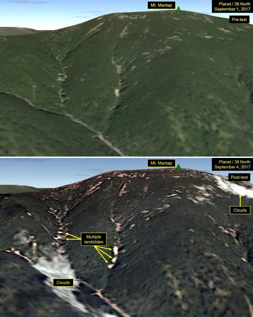
Figure 1. Satellite images of Mt. Mantap before (upper)
and after (lower) the 2017 test (Source: Planet Labs)
There appears to be no evidence of a surface crater that would have formed if the cavern carved out within the mountain by the blast strength and high temperatures had abruptly collapsed. Shortly after the detonation, though, smaller shock waves caused by a collapse might have produced a surface crater.
In Figure 2, arrows indicate horizontal displacement, while color indicates vertical motion.[9] The explosion caused significant surface disturbance and bulky displacements over an area of 9 km2 outlined in black. Thin gray lines are topographic contours at 100 m intervals. Red stars indicate the locations of previous nuclear tests. Balls are locations and magnitudes of the explosion (black) and aftershock (white).
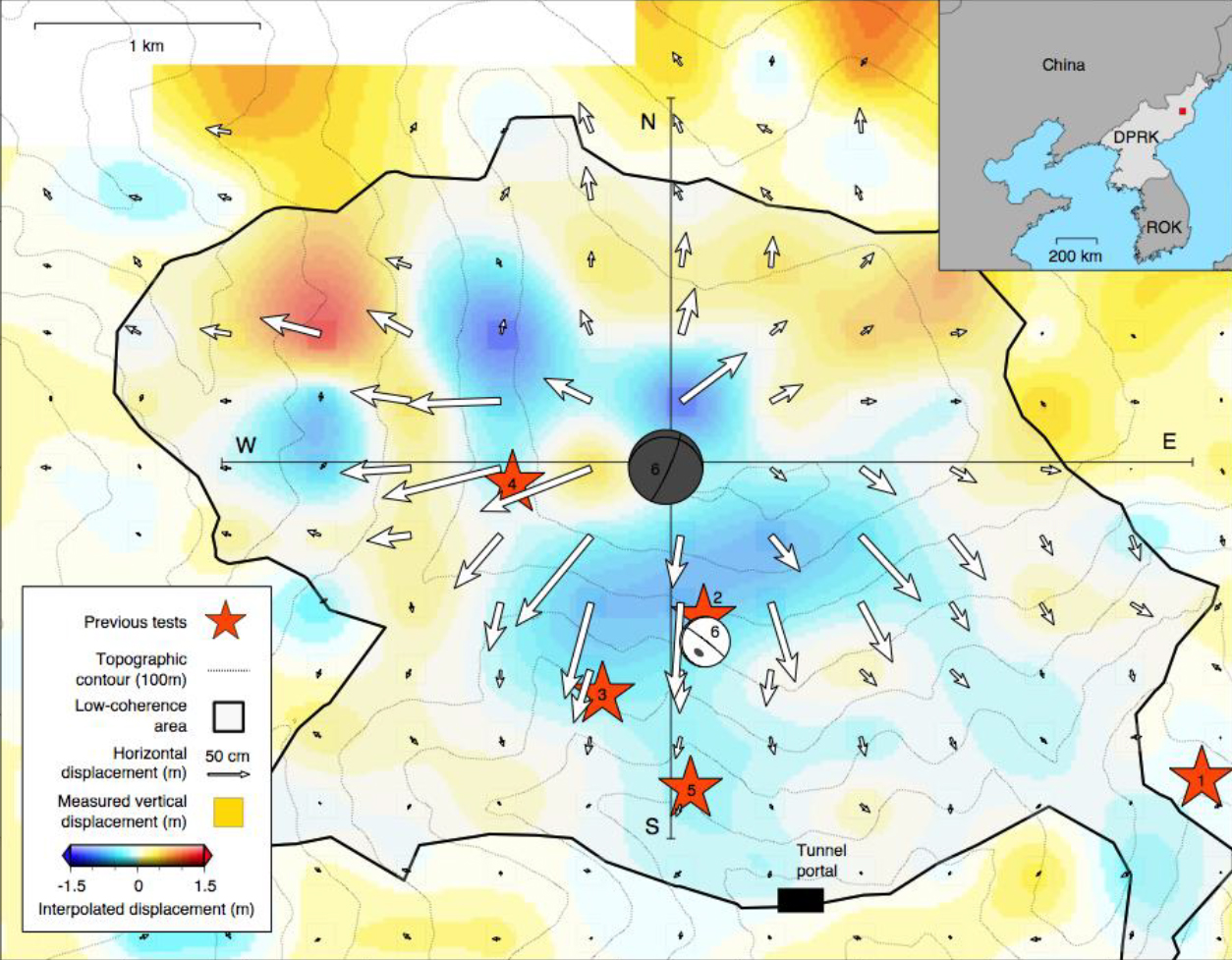
Figure 2. Ground movement on Mt. Mantap caused
by the 2017 test[9]
That explosion rocked the area like a 5.2 magnitude earthquake. Seismic recordings from global and regional networks, and before-and-after radar measurements of the ground surface show that the underground nuclear blast pushed the surface of Mt. Mantap outward by as much as 3.5 m and left the mountain about 50 cm shorter.
Computer modelling of the event helped pinpoint the location of the explosion between 400~600 m right below the 2,200 m peak[9]. Another seismic event, or aftershock, was also located more precisely. That occurred 8.5 minutes after the nuclear explosion, putting it some 700 m south of the bomb blast. This is about halfway between the site of the nuclear detonation and an access tunnel entrance and may have been caused by the collapse of part of the tunnel or of a cavity resulting from a previous nuclear explosion.
The interferometric graphic obtained through the processing of radar imagery of the area encompassing the Punggye-ri site was overlain on Google Earth in Figure 3. The overall centralization of the radar-detected displacements encompassing all of Mt. Mantap provides additional empirical evidence that the sixth nuclear test occurred directly under the peak.[10]
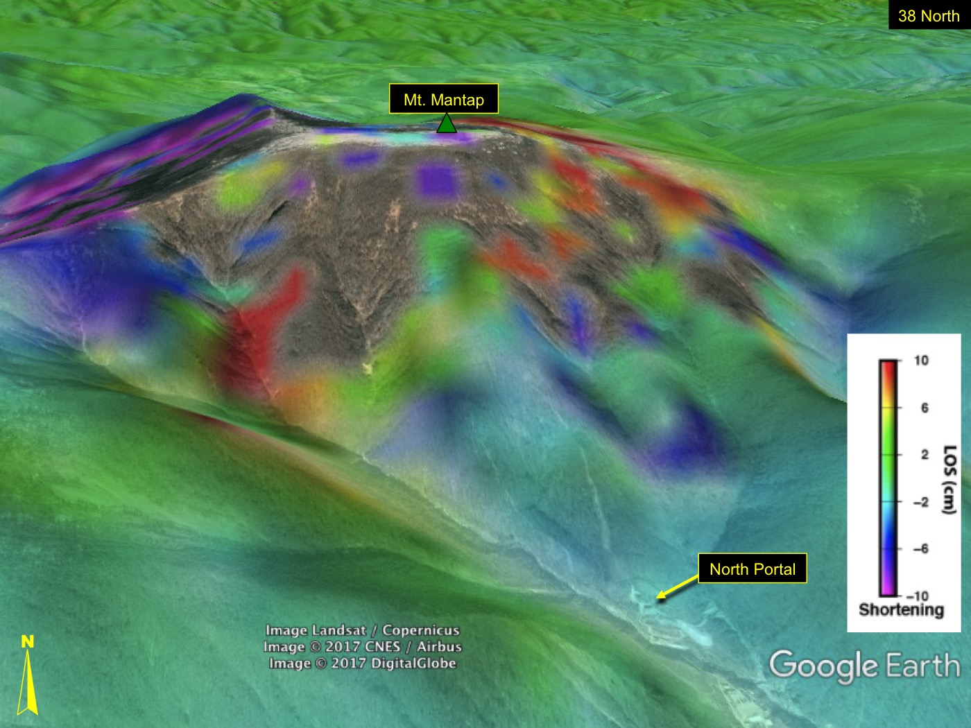
Figure 3. Punggye-ri site overlain on Google
Earth (Source: Dr. Meng “Matt” Wei[10])
There have so far been several detected and reported earthquake-like events subsequent to the sixth 6.3 magnitude underground nuclear test. As such, the site may no longer be suitable for further underground nuclear testing. The three earthquakes were likely induced by the ~250 kt nuclear test. However, US nuclear test history at the Nevada Test Site provides evidence that such post-test tremors are not unusual. Furthermore, even in the face of what has been dubbed “Tired Mountain Syndrome,” abandonment of the site for nuclear testing should not be expected. Such historical precedent, combined with the presence of two other, as yet unused tunnel complexes within the test site, leads to conclusion that there is no valid reason to assume that the Punggye-ri test site is unable to contain additional underground nuclear tests. Should another nuclear test(s) be done in the foreseeable months, it should not be surprising that there shall be further post-test earthquakes.
Literature Cited
1. O.A. Pavlovski, “Radiological Consequences of Nuclear Testing for the Population of the Former USSR (Input Information, Models, Dose, and Risk Estimates),” Atmospheric Nuclear Tests, Springer Berlin Heidelberg, pp. 219~260, doi:10.1007/978-3-662-03610-5_17, ISBN 978-3-642-08359-4, 14 August 1998.
2. V.V. Adushkin, W. Leith, “The Containment of Soviet Underground Nuclear Explosions (PDF),” United States Geological Survey, pp. 35~37, Open File Report 01-312, September 2001.
3. L. Eric, J.R. Matzko, “Physical Environment of the Underground Nuclear Test Site on Novaya Zemlya, Russia (PDF),” United States Geological Survey, pp. 4, 8~10, 20, Open File Report 93-501, 1993.
4. J. van Ginneken, “Collective Behavior and Public Opinion: Rapid Shifts in Opinion and Communication,” European Institute for the Media Series, Taylor & Francis, p. 126, ISBN 978-1-135-62903-8, 2003.
5. “The Containment of Underground Nuclear Explosions (PDF),” US Congress, Office of Technology Assessment, p. 51, LCCN 89-600707, OTA-ISC-414 (full document), October 1989.
6. “Is North Korea’s Nuke-Testing Mountain at Risk of Collapse? Satellite imagery suggests the underground blasts may be taking their toll,” Popular Mechanics, October 20, 2017.
7. “N. Korea nuclear test site may have ‘Tired Mountain Syndrome’,” Agence France-Presse–via Straits Times, 19 October 2017.
8. A. Fifield, “After six tests, the mountain hosting North Korea’s nuclear blasts may be exhausted,” The Washington Post, 20 October 2017.
9. https://news.berkeley.edu/2018/05/10/radar-reveals-details-of-mountain-collapse-after-north-koreas-most-recent-nuclear-test/
10. https://www.38north.org/2017/10/mtmantap101717/