


Kune Y. Suh
Prof. Emeritus of Nuclear Engineering Seoul National University
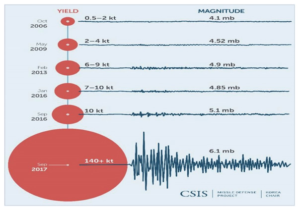
Figure 1. North Korean nuclear tests and their seismic impact, October 2006 to September 2017
(Yield in 1,000 tonnes (kt) TNT equivalent. Magnitude (mb)=Strength of the seismic waves)
Groundwater may contain radioactive substances that can be hazardous to human health. Concentrations of radionuclides Po, Th, U, and Ra were measured in groundwater samples collected from different locations in the area of the Waste Isolation Pilot Plant (WIPP) site in Carlsbad, New Mexico, United States.
In 1979, Congress authorized WIPP, and the facility was constructed during the 1980s. Congress limited WIPP to the disposal of defense-generated transuranic (TRU) wastes in the 1992 Land Withdrawal Act. In 1998, the US Environmental Protection Agency (EPA) certified WIPP for safe, long-term disposal of TRU wastes.[1]
The average values of gross activity concentrations of Po-210, Th-228, U-238, U-234, Ra-226 and Ra-228 were determined to be 1.62 Bq/L in shallow groundwater and 5.88 Bq/L in deep groundwater, respectively. The total radioactivity in deep groundwater was higher than that in shallow groundwater, and most of the radioactivity resulted from Ra-226.
Furthermore, the effective doses for ingestion of radionuclides were ~0.333 mSv/y for shallow groundwater and ~1.338 mSv/y for deep groundwater samples, which are higher than the World Health Organization (WHO) guideline level of 0.1 mSv/y for drinking water. Ra dominated the total ingestion dose, contributing 93 % and 75 % of the total effective doses to the deep and shallow groundwater, respectively.
The ingrowth and decay of natural radionuclides suggested that Ra-228/Ra-226 ratio can be a useful indicator of the source of radioactive contamination. The radioactivity data obtained from the investigated groundwater samples was used to establish a baseline for radioactivity levels in groundwater.
As the Cold War began to heat up, the US wanted a testing site for observing nuclear weapon usage, effect, and strategic implementation. They selected a site ~160 km southeast of the Nye County seat of Tonopah, and ~100 km northwest of the greater Las Vegas area.
The Nevada Test Site (NTS) was home to 100 atmospheric and 828 underground tests. It was located in an extremely rural, flat area that offered security and secrecy. The area was not heavily populated by animals, nor was there a major river nearby, which mitigated environmental impacts.
However, the extremely rural nature of the site made it difficult to locate all families that might be living nearby. Without the knowledge that they were there, the government failed to adequately warn people who may have been affected by radioactive fallout from the nuclear tests.[2]
In 1950, Enrico Fermi and Edward Teller discussed the NTS location. Both concluded there was risk in the site’s location. However, if a maximum yield quantity was observed and if test dates were chosen by meteorologists to limit radioactive fallout dispersion, it was determined the NTS would work. Neither of these recommendations were strictly adhered to in subsequent years.[3]
Furthermore, many of the communities in the surrounding ranch towns were subsistence farmers, and consumed locally produced milk, beef, and vegetables, all of which were exposed to fallout from the tests. The combination of these factors made the Nevada downwinders especially vulnerable to radiation exposure.
Many of these soldiers became known as ‘atomic veterans.’ Some of the civilian population exposed themselves by going to designated areas to watch the blasts. Many brought their breakfasts for the early morning blasts and conversed with their neighbors excitedly. Other civilians were more cautious, staying indoors for hours at a time following the blasts.
Anger mounted throughout downwinder communities as various government documents came to light and cancer rates continued to soar into the 1970s. Leukemia rates in downwind Utah Mormon communities exceeded their non-downwind counterparts by five times. Pockets of thyroid cancer, especially in young children, spiked in areas which had never experienced childhood cancers.
Unlike some other downwinder communities, the first generation survivors in the Nevada range have received compensation for their illnesses. Second and third generation downwinders, however, continue their legal struggle to be recognized as an impacted community. To date, none of these individuals have received reparations, even though many of them suffer pre-existing diseases and conditions they believe are associated with their residency near the NTS.[2,3]
Now, back to Mt. Mantap finally. A multidisciplinary approach is required to identify how North Korea’s nuclear tests have affected the environment and inhabitants in the vicinity of the Punggye-ri Test Site (PTS). Their nuclear tests summarized in Figure 1[4] and ensuing environmental destruction appear to be surfacing as a palpable threat to the environment of the Korean Peninsula at this time. Thus, quantifying environmental damage and taking countermeasures in advance are crucial to minimize their potential threats to humans, flora and fauna. Note that the sixth test with 140+ kt yield is underestimated, though.
Primarily, there is a pressing need to study the environmental impact of North Korea’s nuclear tests using Google Earth image analysis. We need to be able to compare Google Earth images taken before and after each nuclear test. We need to cross-check the results with those of previous scientific research available in the literature.[5]
Forests were already found to be sizably reduced after the first through third tests. In particular, when comparing the Google Earth images before and after the second nuclear test, some ground subsidences were observed. Such subsidences can cause tunnels on the mountainsides and cracks in rocks around the mountains, leading to the release of radioactive materials and contaminating groundwater.[5]
Moreover, decay and deforestation were observed not in the PTS, but in their surrounding areas after the fourth through sixth tests. Particularly after the fifth and sixth tests, the topography and the forests of the surrounding areas were severely damaged.
In relation to North Korea’s nuclear tests and their impact on the environment, there is a need to prepare various policy measures to reduce North Korea’s environmental pollution and destruction. The policy measures shall include the establishment of various cooperative governance between the Korean government, the private sector, the academia, nongovernment organizations (NGOs), and multinational as well as multilateral organizations.
Recently, the Transitional Justice Working Group (TJWG) based in Seoul, has brought to our attention that the PTS is located in an area with a lot of rain and groundwater.[6] The report reveals that out of ~1.08 million inhabitants thereabout, those affected by irradiation is estimated to be 540,000 assuming 50%, and 270,000 assuming 25% of the total population. The report also said that radioactive materials could contaminate agricultural and marine products as well. It appears probable that North Korea’s agricultural and marine products manage to find ways to neighboring markets such as in South Korea, China and Japan.
Meanwhile the South And North Development (SAND) has conducted interviews with three North Korean defectors who went through the sixth test at Gilju County.[7] As a result, statements were made that the earth shaking was particularly sizable during the sixth test in 2017. Since 2013, right after the third test, there was a significant increase in patients with low white blood cells and respiratory infections at Gilju Hospital. It was also argued that North Korean authorities provided bottled water only to the elite class due to concerns about radioactive contamination in drinking water after the sixth test.
Now that groundwater, surface soils, and test facilities are contaminated surrounding the PTS, there is a need to set up a so-called Korean-Peninsula Atoms Management Program (KAMP). KAMP is slated to be responsible for survey and monitoring of the radioactive PTS, as well as for future cleanup and waste disposal for both on- and off-site generators. KAMP shall be responsible for environmental corrective actions and inhabitants’ health care programs with a particular mission to treat groundwater contaminated by nuclear tests. Cleanup has to be done at all surface soils as well.
For groundwater contamination, KAMP shall be working to identify contaminant boundaries, restrict access to contaminated groundwater, and to implement a long-term monitoring program. Because of the complex yet not well known, geology of the PTS, groundwater contamination shall be grouped into characterization areas based on location and similar geology.
Literature Cited
1. “U.S. Department of Energy's Waste Isolation Pilot Plant - WIPP Site,” 8 November 2022.
2. S.A. Fox, “Downwind: A People's History of the Nuclear West,” Lincoln, Nebraska: University of Nebraska Press, Bison Books, 2014.
3. C. Gallagher, “American Ground Zero: The Secret Nuclear War,” New York: Random House, 1994.
4. H.G. Hilpert, O. Meier (Eds.), “Facets of the North Korea conflict: Actors, problems and Europe’s interests,” SWP Research Paper, German Institute for International and Security Affairs, 2018.
5. J.H. Ki, M.K. Sung, C.I. Choi, “Impact of Nuclear Tests on Deforestation in North Korea using Google Earth-Based Spatial Images,” Journal of People, Plants, and Environment, Vol. 22, No. 6, pp. 563~573, 31 December 2019, doi: https://doi.org/10.11628/ksppe.2019.22.6.563.
6. Transitional Justice Working Group, “Mapping the Risk and Effect of Radioactive Contamination of Groundwater Sources from the Punggye-ri Nuclear Test Site in North Korea,” Special Report, February 2023.
7. https://sand.or.kr/kr/index.php.
-
PREV [Feature Article]
-
NEXT [Feature Article]